
It’s a simple question, really.
When I first moved here, I struggled to adapt to just how vast Los Angeles is. This is not a novel observation, certainly; I imagine that if you polled random Americans, the first adjectives that would come to mind when describing LA would be:
- Sprawling
- Dirty
- Unsafe
- Liberal
- Shithole
- Hot
- Dry
Before I arrived here, I didn’t have many preconceived notions aside from the fact that there was a company there willing to pay me to perform work, so I moved in, settled down, and began living life a little more sun-kissed than before. Back to the question at hand: there are some pretty specific contextual rules I need to lay down before we continue. Rephrased, “What is the best scenic drive you can take in the Greater Los Angeles Combined Statistical Area from one gas station to another, traveling in a reference car with reference fuel mileage and a reference gas tank at a reference time of day?”
A little less punchy, huh?
Our objective here is simple: determine the best way to expend our pricey, precious, polluting petrochemicals such that we maximize our enjoyment on a trip starting and ending at gas stations. How hard can that be? Obviously, this is an impossibly subjective task. What I find to be a nice route may not be what you, dear reader, find to be a nice route. Alas, I will have to use some hefty judgment and defer to my own preferences.
A New Playground
I grew up in the Midwest, another part of the country shaped by the automobile. I really do appreciate a scenic drive. In fact, driving around the various twisty roads nearby was the first thing that made me start to think of LA as a place I could maybe like one day rather than just a place I would forget after moving away from in a few years. Flyover country has many redeeming qualities, but sorely lacks the distinct and varied landscapes of Southern California. Where I come from, we have two, maybe three hills in the state and you can be sure everyone rushes to slap on their skis and descend those rare slopes after a two-hour drive once the snow starts to fall. From the 6th Street bridge, if you drive an hour in any cardinal direction (depending on the traffic on the 110), you will end up in four different biomes. The beach, the mountains, the forest, and the desert are all within a podcast episode of downtown. As a new resident, this presented me with a whole host of exciting weekend trips. Snow atop the San Gabriel range in May? Freezing temperatures in Anza Borrego at night? Forested mountains as far as the eye can see in Ojai? Ocean-bound canyon roads from the Palisades to Oxnard? If you’re willing to adjust your seat, slap on your Discover Weekly, and sit in some traffic, you can experience some of “the most breathtaking landscapes god has to offer” (original tweet is, gone this will have to do). Don’t get me wrong: the ANF ain’t exactly Yosemite, but the fact that you can get to something ~70% as beautiful 45 minutes from downtown? That’s pretty rad.
Ruler, Compass, Scale
As I am wont to do, I’ve been rambling. Let’s get down to business here. Start at a gas station. Drive. End at a gas station. This is like verifying a cryptographic hash, where it will be very easy to assess if the route is excellent by observation, but very difficult to determine a good route analytically. Like any first-order calculation, I’ll make some general assumptions to bound our analysis and revisit them later. These assumptions are:
- You are driving in a car with a range of 250 miles, unaffected by grade/speed/weather
- You do not need to have expended your entire tank when you arrive at your destination gas station
- You are not slowed down by traffic, nor do you hit any red lights
- You are allowed to double back, but each segment on the same route is graded separately
Now onto how we will evaluate the “best-ness” of each tank. As alluded to before, this is subjective. However, each subject should consider this to be the route with the most “wow!”s, “holy shit”s, “that’s insane”s, or similar reactions per mile traveled. This is not about wow’s per hour, it’s about wow’s per mile. A side-effect of this is that seeing a lot of the same type of landscape will beget fewer and fewer wows per mile, so this should encourage us to shake things up scenery-wise. I will give extra credit for routes that pass by classic LA landmarks and coffee shops that I personally like. Now that we have a basic evaluation framework, let’s turn our attention to the route itself. Gas stations are numerous around these parts, so I think this will come down to finding gas stations closest to the best route rather than trying to work from the gas station forward. This may prove to be foolish, but I am nothing if not a fool.
Malibu Canyons

I don’t think you can talk about scenic drives and beautiful vistas around LA without mentioning the Malibu Canyons. In my opinion, “the canyons” are bounded by Sunset Blvd to the east, Mulholland Highway to the north, Deer Creek Canyon to the West, and the venerable PCH to the south. This quadrangle envelopes some of the finest roads I’ve ever seen. Mulholland forms a backbone from which any left turn will take you to the sea. From the savage guard-rail-free curves of La Tuna to the endless switchbacks of Latigo, Malibu really has my number when it comes to getting out of the city for an afternoon. It’s fairly accessible from the north and the east, making it a strong contender in this search. There aren’t too many gas stations in the western edge so trips ending in western Malibu may really be ending in Point Dume, many junk miles away from the exits of some of the best canyons.
Angeles Crest Highway
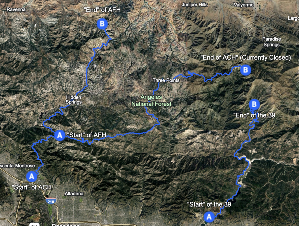
Another classic is the ACH. The Angeles Crest Highway runs from where the 2 ends in La Cañada all the way through the ANF out to the desert (I think it keeps going east after the mountains. Need to do some more research). It has many fewer alternate routes as compared to Malibu (AFH being a notable exception, but who wants to end up in Palmdale?), but on the right day at the right time it provides some excellent views of the city. It’s certainly a much more “dramatic” road than anything Malibu has to offer. Well-maintained tarmac surrounded by sheer mountain walls and steep cliffs make this a lot more of a dangerous feeling drive than the coast, and that’s a good thing in my book. Another point in its favor is the fact that you start at a few hundred feet above sea level and climb up the side of a mountain through a forest. That’s pretty sweet. There is no gas after civilization so you are a lot more limited on where this road falls in your trip. An honorable mention in this neck of the woods is the 39. This road used to be connected to the ACH but is no longer and Caltrans does not appear to be working to make it happen anytime soon. Dollars for donuts, the 39 is probably my favorite road to ride a motorcycle on in SoCal, but its current dead-end status makes it a tough sell for this quest with so many freeway miles to get there.
Also-Rans
Some other areas worth mentioning are:
Palos Verdes
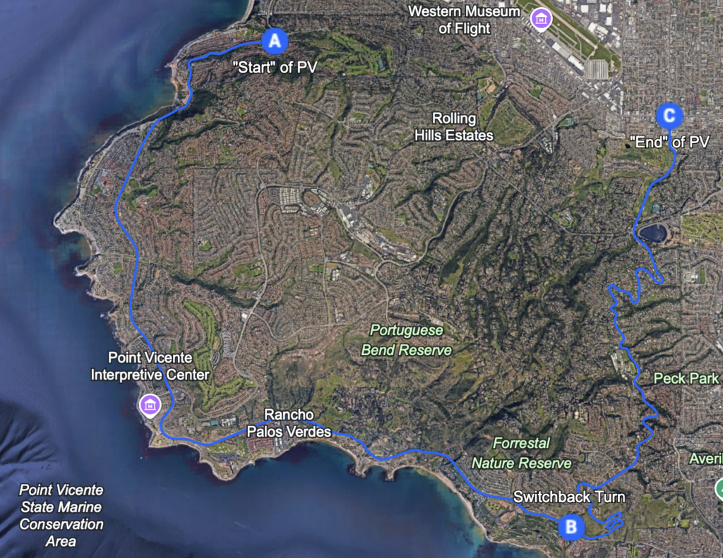
Amazing cliffside ocean views with East Palos Verdes Drive presenting some lovely switchbacks followed by a tight section exposed to the port of Long Beach. Around sunset, this is an insane view. Too bad it’s located in no-mans-land in the South Bay and has some well-publicized road quality issues on the way to the good stuff.
Hollywood Hills/Canyons
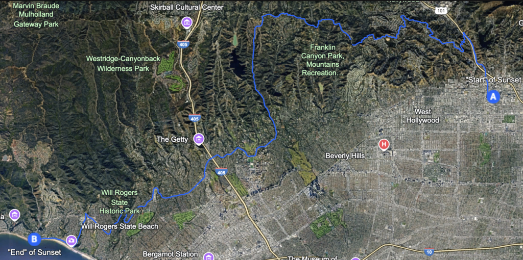
IDK if this is the correct term but the stuff east of Sunset all the way to, oh, I don’t know, Laurel Canyon? Some hidden gems there supported by Mulholland Drive (different than Mulholland Highway!) to the north. Provides views of downtown and the valley. Potentially a nice way to link up Malibu and the ACH.
Grimes Canyon (CA 23)
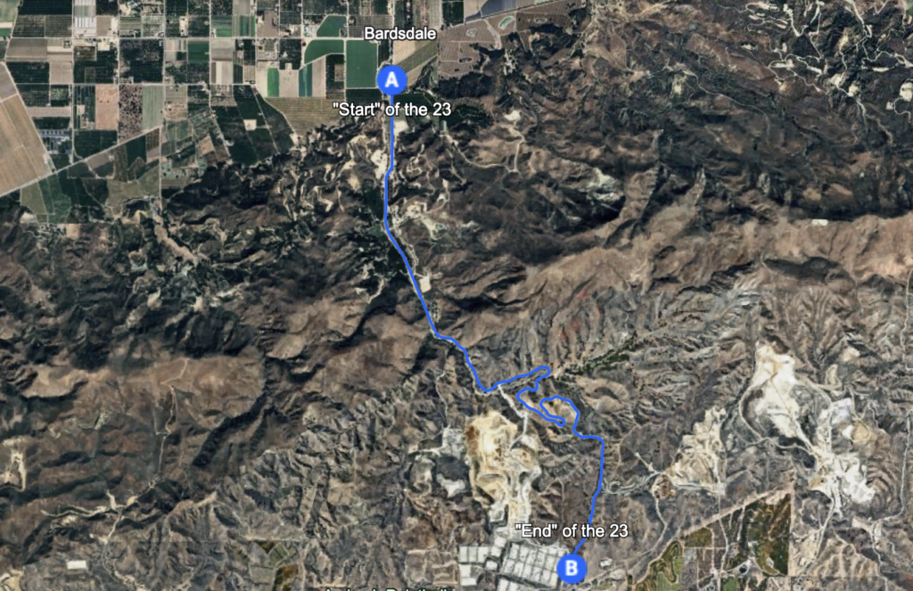
I doubt this will make the cut, but this is a lovely set of turns stuck between the Santa Paula Valley and the Santa Monica Range. It’s pretty isolated, but if you are in the area, stop by the fruit stands outside of Fillmore and then take this down to the 101! Wild off-camber turns and excellent views make this worth a day trip.
Ortega Highway (CA 74)
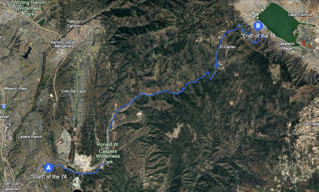
Also probably too far away, this starts near where the PCH ends in Dana Point and takes you from Orange to Riverside (you can tell at the county line who funds their road work crews more, yeesh) all the way to Lake Elsinore. Lovely gentle climb up a forested mountain area ending at a dramatic cliff edge with switchbacks down to the lake. Worth a drive out and a night under the stars in the Cleveland National Forest down there.
Highway 33
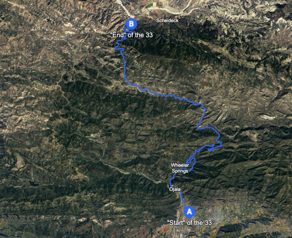
Now I’m really getting far away, but I couldn’t bring myself to leave this one out. Doable as a day trip, the 33 winds from Ojai all the way through the Los Padres National Forest’s northern edge (in that area). On it, you’ll begin at the base of the mountains and wind up to a stunning overlook north of Wheeler Springs. Following that, you’ll meander through the mountains until you find a campsite for the night or decide you need to turn back home.
There are other nooks and a few crannies I’m leaving out, but I think this is a decent first pass at what I view as the most likely settings for this odyssey. In subsequent updates I’ll workshop a few initial route plans and begin building some tools to help me out. Once we have some prototypes, I’ll evaluate the top few options in person. All the theory in the world means nothing without some hard data, and there’s a lot of data to gather on Encinal Canyon at midnight.
LA public transit has gotten better every year I’ve lived here. Right now, you can live without a car and commute, play, and explore around a lot of the city with only your TAP card and a sense of adventure. Ultimately, Los Angeles and the humble automobile are still very much joined at the hip. I would imagine that for some people, their best tank of gas may have been the one they pushed to fumes until they stopped at the Mobil in Sherman Oaks on the 405 the night they moved to the city, or perhaps the tank they filled bleary-eyed at 5 in the morning at the Sinclair on Alameda as the topped up for the last time on their way to somewhere else. For a city that is so defined, for better or worse, by its relationship with the automobile, I hope I can help you, dear reader, appreciate the road less traveled.


Leave a Reply